

Open Educational Resources (OER) are a “part of the global open content movement, are shared teaching, learning, and research resources available under legally recognized open licenses — free for people to reuse, revise, remix, and redistribute.” (Edutopia) The Texas Legislature has recently sent strong signals that Texas districts should take advantage of these resources. Why are high quality OER resources important?
- They save teachers time and effort.
- They can help to fuel collaboration.
- They encourage the improvement of available materials.
- They aid in the dissemination of best practices.
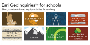 A perfect exemplar of OER activities created for English, math, science, and social studies are GeoInquiries; they enhance key content concepts using the free ArcGIS Online geographic mapping website. These content collections, created by teachers for teachers, contain 15 free activities that correspond to and extend map-based concepts in leading textbooks. The activities use a standard inquiry-based instructional model, require only 15 minutes for a teacher to deliver, and are device agnostic. The activities harmonize with the standards for each content area. Current collections include:
| Earth Systems Science | AP Human Geography |
| Mathematics | U.S. History |
| American Literature | Elementary |
| World History | Environmental Science |
![]() GeoInquiries can be used out of the box or customized, and since they are in the Creative Commons, they make a great starting point to meet the needs of a changing classroom. Thanks to the new “Hacking GeoInquiries” wiki, teachers now have a guide with suggestions for going further and customizing the data or instructional activities included in the GeoInquiries to better meet student needs.
GeoInquiries can be used out of the box or customized, and since they are in the Creative Commons, they make a great starting point to meet the needs of a changing classroom. Thanks to the new “Hacking GeoInquiries” wiki, teachers now have a guide with suggestions for going further and customizing the data or instructional activities included in the GeoInquiries to better meet student needs.
ESRI, the software company who created ArcGIS Online, contracted with teachers who have been teaching for years with the geographic mapping web interface to teach content to students. These teacher developers created 120 activities and maps using over 750 data sets, creating limitless content connections and combinations. As a testament to the quality of the materials, there has been a steady increase in downloads of the activities, topping 70,000 a month. States like Virginia, Arkansas, and New Hampshire have the heaviest use with special interest in U.S. History and AP Human Geography.
In addition to the creation of the national standards-based GeoInquiries, there are state initiatives in Texas, Georgia, and Minnesota to create state curriculum-driven GeoInquiry OERs. For example, in Texas, the education focus group requested middle school Texas state history GeoInquiries, and a teacher group is currently developing those.
These resources are shared using the Creative Commons B/NC/SA license. This license lets others remix, tweak, and build upon your work non-commercially and commercially, as long as they credit you and license their new creations under the identical terms. This means you can adapt the lessons to meet the needs of your students and to align with your state’s standards. Check out these resources to see how they can be used with your students.
This post was written by Tom Baker and Anita Palmer. Tom is an education outreach manager for ESRI. He specializes in curriculum development, teacher education, and research. Anita Palmer of GISetc, is a past technology teacher who specializes in teacher professional development and curriculum design and development.
Photo Credit: Compass by Calsidyrose